Boppard, formerly also spelled Boppart, is a great place from which to explore the surrounding towns and villages of the Upper Middle Rhine Valley, which stretches 65 kilometers from Koblenz to Rudesheim. It is a town and municipality (since the 1976 inclusion of 9 neighboring villages, Ortsbezirken) in the Rhein-Hunsrück-Kreis (district) in Rhineland-Palatinate, Germany, lying in the Rhine Gorge, a UNESCO World Heritage Site. The town is also a state-recognized tourism resort (Fremdenverkehrsort) and is a winegrowing center.
The city was the site of an early Celtic settlement and of the Roman fort of Baudobriga, from which the modern name is derived. Under the Merovingian dynasty, it became a royal residence. During the Middle Ages, it was a considerable center of commerce and shipping, and under the Hohenstaufen emperors, it became a free imperial city. In 1312, however, Emperor Henry VII pledged the town to his brother Baldwin, archbishop-elector of Trier, and it remained in the possession of the electors for centuries. It was assigned to Prussia by the Congress of Vienna in 1815.
Boppard lies on the upper Middle Rhine, often known as the Rhine Gorge. This characteristic narrow form of valley arose from downward erosion of the Rhine’s riverbed. Since 2002, the Gorge has been a UNESCO World Heritage Site. A 17 km stretch of the Rhine forms the town’s eastern limit. Along this part of the river lie the outlying centers of Hirzenach and Bad Salzig, as well as the town’s main center, also called Boppard.
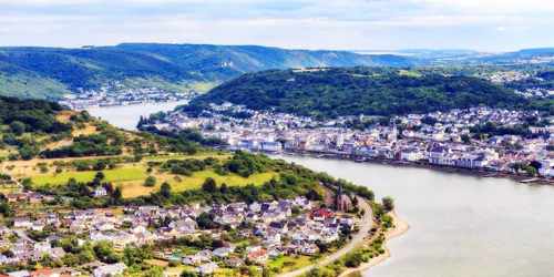
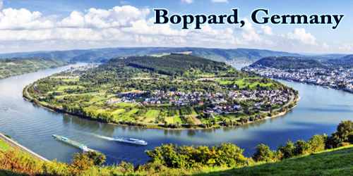
Directly north of Boppard, the Rhine takes its greatest bend. This bow is called the Bopparder Hamm, although this name is more commonly applied to the winegrowing area found along with it. The best-known lookout point over this bow in the Rhine is the Vierseenblick, or “Four-Lake View”. This vista gets its name from the way in which the Rhine can be seen from here, or rather the way in which it cannot be seen: hills block out most of the view of the river itself so that visitors can only see four apparently separate patches of water, rather like four lakes. These are all actually parts of the Rhine; there are no lakes to be seen. The Vierseenblick can be reached by chairlift.
Boppard’s town forest is the second biggest in Rhineland-Palatinate with an area of 43.6 km².
Since 1969, the town of Boppard has belonged to the Rhein-Hunsrück-Kreis and is the district’s northernmost municipality. Boppard is a middle center; the nearest upper center is Koblenz, some 22 km away.
The town itself is situated on the largest bend of the Rhine River and dates back to Roman times. It’s pretty medieval center features cobblestone streets, a market square and a good selection of shops and restaurants.
Enjoy a stroll along the riverside promenade or hop aboard a river cruise boat for a relaxing look at the valley from the water. The cliffs on either side of the river are planted with vines and dotted with ruined castles, so there’s plenty to see.
People in Boppard speak a dialect known as Bubberder Platt, Bubberder being the dialectal form of Bopparder. Platt is a word used to designate a dialect; it does not refer here to Plattdeutsch (that is, Low German), for Bubberder Platt actually belongs to the Moselle Franconian dialects, and is closely akin to Luxembourgish. A certain degree of kinship with Rhenish and Hessian speech can also be heard. Furthermore, Bubberder Platt also features sporadic Yiddish influences, for until the time of the Third Reich, Boppard had a considerable Jewish community. Outlying Ortsbezirke, too, has their own local Moselle Franconian forms of speech. South of Boppard runs the “Boppard Line”, a linguistic boundary that marks the separation of speech populations who say Korf (to the north) or Korb (to the south).
Boppard is still partly surrounded by medieval walls, and its picturesque appearance has made it a center of tourism. There is also a diversified light industrial sector, with products including machinery and pharmaceuticals. Notable buildings include the Romanesque Church of St. Severus (12th–13th centuries), the Gothic Carmelite Church (14th century), and the archbishop’s castle (14th century), which now houses the municipal museum. The city also has a spa with mineral springs.
The museum is housed in the old Electoral castle. On permanent display, there are exhibits about the town’s history, Michael Thonet and his bentwood furniture, the composer Engelbert Humperdinck and other people somehow linked with the town. In November 2009, the museum was closed for four years for a thorough €9,000,000 renovations. This work on the castle building will be financed mainly by the Federal world heritage program.
Information Sources:
