Electric self-driving cars still have a long way to go before they are reliable. Researchers from Western Michigan University and the Department of Energy’s Oak Ridge National Laboratory are collaborating to develop solutions that come from sources other than the automobile, such as sensors and processors that are integrated into the design of roads.
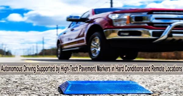
ORNL engineers in collaboration with partners are fitting the reflective raised pavement markers that are already used to help drivers identify lanes with low-powered sensors.
According to a paper in IEEE Sensors by ORNL researcher Ali Ekti with lead author Sachin Sharma of WMU, microchips inside the markers transmit information to passing cars about the road shape. They are effective even when vehicle cameras or remote laser sensing called LiDAR are unreliable because of fog, snow, glare or other obstructions.
“We are working to make autonomous driving features accurate and safe in more remote areas,” Ekti said. “And we are doing it by converting a dummy piece of infrastructure into something with many more uses.”
The technology not only offers more precise information about the road conditions, but it also transfers some of the processing burden from the car’s software to the infrastructure. This increases the driving range of electric vehicles, which encourages wider EV adoption.
The authors claimed in a technical study that the chip-enabled pavement markings can lower navigational power consumption by up to 90% when compared to a leading camera and LiDAR-based autonomous driving solution.
The system has the ability to be used with both today’s and tomorrow’s standard autonomous driving capabilities, such lane assist.
WMU researchers are also using a vehicle driving on a closed course to measure the reduction in vehicle energy use that is enabled by these technologies.
Professor Zachary Asher
The initiative is a component of a wider project run by WMU that teams up with academic and business partners to create relevant sensor and autonomous driving technologies such radar retro-reflectors, high-definition mapping, computational offloading, and weather sensing.
“WMU researchers are also using a vehicle driving on a closed course to measure the reduction in vehicle energy use that is enabled by these technologies,” said Zachary Asher, assistant professor of mechanical and aerospace engineering and director of the WMU Energy Efficient and Autonomous Vehicles Lab.
ORNL researchers tested the optimal transceiver, battery, and antenna configuration for the sensor package inside both common and snowplow-resistant road markings. They then used a strategy for communication that involves hopping up to 50 times per second across a certain radio frequency range.
“It’s hard to detect, works well against interference, is low cost and doesn’t consume a lot of power,” Ekti said. Adjustments to the equipment could ensure its battery would last for the same replacement cycle as the pavement markers, typically a year.
Ekti’s team created algorithms that triangulate among the GPS coordinates of lane markers to reconstruct an image of the drivable area. A pavement marker’s microchip contains one algorithm, while the software of the car contains a decoding algorithm.
The sensor platform was field-tested by ORNL researchers in several weather scenarios in a secluded national park in Montana without wireless connectivity. They found that it transmits more than five times beyond the original 100-meter goal.
“It’s amazing how far it can transmit over hills, in snow. It’s a big deal,” Asher said. “Every step of the way, we’re surprised at how well this technology is working, and we’re finding some really cool ways it could be integrated.”
“The sensors could also signal temporary lane shifts or closures in construction zones when high-definition maps might be out of date. Marker sensors could eventually convey information about temperature, humidity and traffic volume,” Ekti said.
The project team intends to engage with students to create a more affordable alternative to more expensive off-the-shelf products by creating a smaller microprocessor for the markers.
Asher is planning road demonstrations for stakeholders including the Tennessee and Michigan departments of transportation, the Michigan Office of Future Mobility and the City of Chattanooga.
“These government agencies decide which technologies are implemented in infrastructure, so their involvement in the development process is critical,” Asher said.
“Venture capitalists and Silicon Valley have typically regarded self-driving vehicles as a software problem,” Asher said.
“With the hindsight of 10 years of highly funded development, we now know that software and cameras alone don’t provide an easy solution,” he said. “Perhaps a more patient approach, using infrastructure-based hardware in coordination with government transportation agencies, is the way to achieve zero-accident vehicles which actually use energy sustainably.”
Part of the ORNL research was conducted at DOE’s National Transportation Research Center. The Vehicle Technologies Office under DOE’s Office of Energy Efficiency and Renewable Energy provided funding. Contributing ORNL researchers include Ross Wang, Jason Richards, Elizabeth Piersall, David Pesin, Ozgur Alaca and Shean Huff.