ESA’s novel Aeolus satellite reliably measures wind speed also in higher air layers, and thus in a region of the atmosphere where other direct global wind measurements are relatively scarce. This is the result of a study in which satellite data was compared to wind observations from stratospheric balloons. Stratospheric balloons would provide highly accurate data on horizontal wind speed and would thus be suitable for the validation of future satellite missions.
Future wind satellites should increase the vertical resolution to better resolve gravity waves in the tropics, writes the team of researchers from the Leibniz Institute for Tropospheric Research (TROPOS), the European Space Agency (ESA), the European Centre for Medium-Range Weather Forecasts (ECMWF), the University of Hamburg and the Google company Loon. The study has now been published in the Quarterly Journal of the Royal Meteorological Society.
The quality of numerical weather prediction models, and thus of weather forecasts, is heavily dependent on the data available. As a result, in recent decades, a global observation system has been built that includes wind profiles from weather balloons, aircraft data, and wind profiler radar systems. However, the vast majority of this information comes from the densely populated northern hemisphere. The network of direct measurements is still relatively sparse in the southern hemisphere, over the oceans, and especially in the tropics.
Our analysis confirms that the Aeolus satellite provides almost bias-free wind measurements in the upper troposphere and lower stratosphere. These results are important to better understand dynamical processes in the upper troposphere and lower stratosphere and to further improve the weather models.
Dr. Sebastian Bley
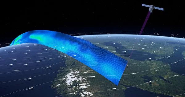
The launch of the European Space Agency’s (ESA) first wind satellite Aeolus on 22 August 2018 was thus a significant step toward global wind measurements. The Atmospheric Laser Doppler Instrument is a powerful laser on board this novel satellite (ALADIN). ALADIN is the first Doppler wind lidar in space, providing profiles of horizontal wind speed from the Earth’s surface or the tops of thick clouds up to a height of about 30 km on a global scale. As it orbits the Earth, the satellite emits short ultraviolet laser pulses to accomplish this.
A small part of these light pulses is scattered back to the satellite by air molecules, aerosols and clouds and collected and processed in the detector there. For one circumnavigation of the globe Aeolus takes 90 minutes, within a week the satellite collects wind data around the entire globe. This data is assimilated by weather forecasting centres around the world to improve their forecasts. Since there have been no comparable satellite missions so far, the data are checked particularly critically and compared with other wind measurements.
A study recently published used data from 229 stratospheric balloons of the Loon project between July 2019 and December 2020 from tropical Latin America, Atlantic Ocean, Africa and Indian Ocean for comparison. Loon was a commercial project that had provided remote regions with internet access via helium balloons in the stratosphere. The balloons, which were about 12 metres in diameter, acted as floating mobile phone stations at altitudes of 16 to 20 kilometres above the ground.

To keep the network running, the balloons had to automatically correct the wind direction by changing altitude. This resulted in a large data set on wind speeds in these atmospheric layers, which fills a gap in the global observation system’s wind data at this altitude. The Loon project was canceled in 2021 due to financial constraints, but a wealth of data remains for atmospheric research.
“Our analysis confirms that the Aeolus satellite provides almost bias-free wind measurements in the upper troposphere and lower stratosphere. In contrast, the current ECWMF weather model systematically underestimates the wind speed there by about 1 metre per second, which could be demonstrated by the Aeolus and Loon data. These results are important to better understand dynamical processes in the upper troposphere and lower stratosphere and to further improve the weather models,” emphasises Dr. Sebastian Bley from TROPOS, who worked for the study at ESA in Frascati, Italy.
Another suggestion made by the researchers is to take more vertical measurements in order to provide more wind information in the atmospheric layers. This could improve the accuracy of future wind satellites. Aeolus provides information about aerosols and clouds in addition to wind speed, but only through a portion of the backscattered light. “Future wind missions, we hope, will be able to measure depolarisation, or the rotation of light when it is reflected. That would be a significant achievement because the satellite could then provide more information about aerosols” Bley explains.
Aeolus was designed as a three-year-long explorer mission to demonstrate the technology of a Doppler wind lidar in space. However, expectations were exceeded, and Aeolus has now been providing useful data for more than 4 years. Wind data are now used in the weather forecasts of several weather services throughout Europe, including the German Weather Service (DWD), and have proven to be reliable due to their positive impact on forecast quality. The next mission, Aeolus-2, was recently decided in an ESA ministerial and will be developed jointly by ESA and EUMETSAT.