Creating an algorithm to map the safest routes for city cars is a worthwhile project because it can increase road safety and transportation efficiency. To establish the safety of a route, such an algorithm would need to analyze a variety of parameters.
Most navigation applications will show you the quickest route to your destination, and some will even recommend an eco-friendly path calculated to emit the least amount of carbon emissions. But what if they could also plan the safest route with the least chance of a collision?
A new algorithm developed by UBC researchers could make this a reality. Led by Dr. Tarek Sayed, professor in the UBC Department of Civil Engineering, and Ph.D. student Tarek Ghoul, the group developed a new approach that identifies the safest possible route in an urban network using real-time crash risk data, and can be incorporated into navigation apps such as Google Maps.
New possibilities for real-time safety measurement and effective routing emerge when an urban road network has access to new technologies such as autonomous vehicle data, cameras, and other sensing technologies. These technologies are now generating unprecedented amounts of data, giving rise to new smart mobility applications in the future.
Dr. Tarek Sayed
The team collected data from 10 drones hovering above downtown Athens, Greece, for many days, capturing characteristics such as vehicle position, speed, and acceleration. They used this data to identify vehicle collisions and then forecast the risk of a crash in real time.
“This research is the first to use real-time crash risk data to provide navigation directions and give you the safest possible driving route through a city,” Dr. Sayed stated. “The algorithm can adjust directions in real time, recommending detours to avoid hazardous locations. This improves road safety for all users. Companies, for example, will be able to route their fleet more efficiently, prioritizing safety and lowering crash risk.”
Developing a robust algorithm for mapping the safest routes in a city requires continuous data collection, analysis, and refinement. Additionally, collaboration with local authorities and transportation agencies is crucial to ensure the algorithm’s effectiveness in improving road safety.
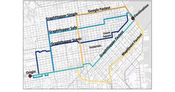
Fastest route not always the safest
The research also discovered that the quickest routes are not always the safest. For example, the researchers examined a tiny piece of Athens’ metropolitan road network and discovered that just 23% of the fastest routes were also regarded the safest. The safest route used 54% of the roads used by the fastest route on average. This suggests that while choosing directions, drivers should consider both safety and efficiency, according to Ghoul.
“In the network we looked at, there was a clear trade-off between safety and mobility: The safest route tended to be 22 per cent safer than the fastest route, while the fastest route was only 11 per cent faster than the safest route. This suggests that there are considerable gains in safety on the safest routes with just a small increase in travel time. As well, intermediate routes, which consider both safety and mobility, would yield larger safety benefits that would by far outweigh the increased travel time.”
Connected cities
The researchers are now expanding their investigation into other places, like Boston, where autonomous vehicles are being tested that generate data not just about themselves and their navigation, but also about traffic patterns and crash risk.
“New possibilities for real-time safety measurement and effective routing emerge when an urban road network has access to new technologies such as autonomous vehicle data, cameras, and other sensing technologies,” stated Dr. Sayed. “These technologies are now generating unprecedented amounts of data, giving rise to new smart mobility applications in the future.”
Because cyclists and pedestrians are among the most susceptible users of road networks, the algorithm could potentially be employed for bike routing. “Including pedestrian and cyclist data in future algorithms or navigation tools will allow us to significantly improve their safety,” Dr. Sayed stated.
He stated that real-time crash risk data should be used in any crash prediction or safety optimization system to reflect current conditions, provide more accurate crash risk estimations, and reduce the frequency of road incidents. Using this data and innovative modeling approaches, a safer route algorithm is created that assists road users in prioritizing safety without sacrificing efficiency.